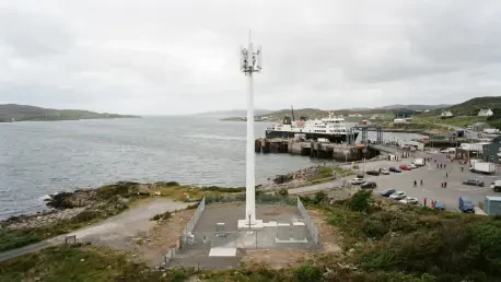

Residents of Lewes Beach remain skeptical about whether the new tower will resolve long-standing service issues or if it is designed primarily to serve transient ferry passengers. This ongoing friction in the coastal city of Lewes, Delaware, highlights a growing national trend where historic preservation and modern digital connectivity collide on valuable public lands. The proposal by AT&T to construct a wireless facility at 43 Cape Henlopen Drive has moved to the forefront of local governance, as the site sits directly across from the Cape May-Lewes Ferry terminal. This location is a critical gateway for the region’s tourism industry, yet it remains one of the most aesthetically sensitive areas in the city. The property is currently owned by the municipality but leased to the Delaware River and Bay Authority, creating a complex web of jurisdictional oversight that has frustrated many residents who feel their voices are being drowned out by high-level inter-agency agreements. As the community moves through 2026, the debate has shifted from simple utility to a broader discussion about the long-term character of the Lewes waterfront.
Technical Specifications and Site Requirements
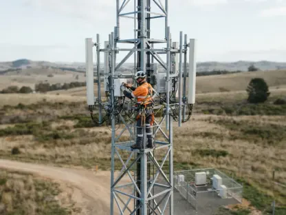
The engineering behind the proposed tower reflects a shift toward more streamlined, less intrusive telecommunications infrastructure, though the scale remains a point of contention. AT&T intends to install an 86-foot monopole, which is essentially a single, sleek pillar that lacks the bulky, triangular lattice framework typical of older cell towers. This structure is intended to support an array of nine panel-style antennas and a specialized lightning rod to protect the sensitive electronics from the frequent coastal storms that define life in Sussex County. Because the site is situated within a designated floodplain, the technical plans include significant environmental mitigation, such as elevating all ground-based equipment at least three feet to avoid water damage. A diesel-powered backup generator is also part of the design, intended to keep emergency communications active during the severe weather events that have become more frequent in recent years. For the city, these specifications represent a standard industrial installation, but for the neighbors, the footprint—roughly the size of a standard school bus—is an unwelcome addition to the scenic landscape.
Addressing Local Coverage Gaps
Telecommunications experts representing the carrier have testified that the area surrounding the ferry terminal is currently suffering from a significant deficiency in wireless network performance. With more than a quarter-million travelers utilizing the ferry annually, the demand for high-speed data and reliable voice services often exceeds the capacity of existing nearby infrastructure. During peak summer months, the congestion on the current network leads to dropped calls and stalled data speeds, which the applicant argues could be a safety hazard in a maritime environment. The proposed facility is being presented as the most efficient way to close this gap, ensuring that both permanent residents and the massive influx of seasonal visitors have access to modern 5G and LTE services. By placing the tower at this specific location, the carrier hopes to provide a seamless handoff for signal coverage as passengers move from the water to the land, effectively creating a dedicated communication corridor for the Cape Henlopen region.
While the primary goal is to boost capacity for transit hubs, the technical argument also touches on the necessity of high-bandwidth connectivity for modern emergency services. Police, fire, and medical responders increasingly rely on dedicated wireless bands to transmit real-time data during incidents at the terminal or on the ferry vessels themselves. AT&T maintains that without this new structure, the digital infrastructure of Lewes will remain stagnant, unable to keep pace with the technological requirements of the mid-2020s. However, this justification has not entirely convinced the local population, many of whom believe that the coverage gap is exaggerated to facilitate a project that primarily benefits the carrier’s broader regional network rather than the immediate neighborhood. The company continues to stand by its data, asserting that a monopole of this height is the minimum requirement to overcome the geographical barriers presented by the coastal terrain and the dense foliage of the nearby state park.
Evaluating Alternative Infrastructure Options
Before settling on the 43 Cape Henlopen Drive location, the applicant conducted a search for existing tall structures within a two-mile radius that might serve as alternative mounting sites. One such location was the Pilots’ Association tower, but structural assessments determined that adding a new array of nine antennas would require a total replacement of the foundation and the pole itself. Similarly, the Delaware River and Bay Authority’s police tower was found to lack the structural integrity to support the specific weight and wind-load requirements of the proposed equipment. These existing assets are already operating at or near their maximum physical capacity, making them unsuitable for the heavy-duty hardware required to resolve current service issues. Furthermore, the use of localized “small cell” technology was dismissed as a viable alternative because such systems cannot handle the high volume of simultaneous connections generated by a departing or arriving ferry boat.
Historical preservation laws also played a significant role in narrowing down the possible sites for the new facility. The region is home to several historic World War II-era watchtowers, which are iconic features of the Delaware coastline and possess the ideal height for signal propagation. However, the Delaware Department of Natural Resources and Environmental Control has strictly prohibited the mounting of commercial equipment on these structures to protect their historical integrity and aesthetic value. This regulatory environment left the carrier with few options outside of constructing a new, dedicated monopole. Despite these explanations, critics in the community remain vocal about the possibility of placing the equipment on non-historic buildings or using more advanced, low-profile antenna technologies that might be less disruptive to the skyline. The current proposal represents the culmination of these site-selection challenges, balancing technical necessity against a complex landscape of legal and physical constraints.
Mobilization of Local Community Opposition
The Lewes Citizen Action Committee has taken a leading role in organizing the neighborhood’s resistance to the cell tower, focusing on the potential loss of the city’s unique coastal charm. Members of the committee have expressed deep concern that the industrial nature of the 86-foot pole will create a permanent eyesore that could negatively impact local property values. Beyond the immediate neighbors, there is a broader fear that allowing such a structure on city-owned land sets a dangerous precedent for future commercial development in the historic district. The group has been active in gathering signatures for petitions and coordinating public testimony to ensure that the City Council understands the depth of local frustration. They argue that the waterfront should be preserved for its natural beauty and recreational value rather than being treated as a convenient utility corridor for large corporations that do not have a permanent stake in the community’s well-being.
Concerns of the Citizen Action Committee
A central theme of the opposition is the perceived lack of benefit for the year-round residents who live in the Lewes Beach area. Many homeowners have pointed out that while they occasionally experience service issues, they do not believe an 86-foot industrial monopole is a proportionate solution to what they characterize as minor inconveniences. The committee has questioned the specific design of the tower’s signal, suggesting that it may be engineered to beam across the Delaware Bay to serve ferry boats rather than providing meaningful relief to the land-based residents of Lewes. This has led to accusations that the city is being asked to bear the visual and environmental burden of a project that serves transient traffic and corporate interests at the expense of local tax-paying citizens. The comparison of the equipment compound to a school bus footprint has become a rallying cry for those who view the project as an oversized intrusion into a delicate coastal ecosystem.
Furthermore, the Citizen Action Committee has raised significant procedural alarms regarding the transparency of the application process. There is a sense among residents that the project has been fast-tracked through various boards without sufficient opportunities for detailed public scrutiny. Leaders of the committee have highlighted the fact that Lewes is a town that prides itself on its “First Town in the First State” heritage, an identity they feel is threatened by the introduction of modern, utilitarian structures that clash with the colonial and maritime aesthetic. By mobilizing residents and engaging legal counsel, the group hopes to force a more rigorous examination of the environmental and economic impacts of the tower. They are calling for independent studies that verify the carrier’s coverage claims and explore less intrusive methods of expanding the network, such as placing equipment on existing commercial buildings further inland or utilizing more sophisticated signal-shaping technologies.
Safety and Environmental Risk Factors
The physical stability of a tall monopole in a coastal zone remains a significant point of concern for both residents and some city officials. Lewes is frequently subject to high-velocity winds and storm surges, leading to fears that a structure built on shifting sands and deep bedrock could pose a safety risk during a catastrophic weather event. While the engineering plans include deep-seated foundations, the community remains skeptical about the long-term integrity of the site, especially as sea levels continue to fluctuate and coastal erosion impacts the surrounding terrain. Opponents have argued that the application lacks substantial evidence to guarantee the safety of the tower over its projected lifespan. There is also the matter of the diesel generator and the fuel storage required for its operation; residents worry about the potential for environmental contamination in the event of a flood, which could allow hazardous materials to enter the sensitive marshlands and waterways nearby.
Environmental critics also point out that the construction of the fenced compound and the access road could disrupt local wildlife habitats and natural drainage patterns. The Cape Henlopen area is home to diverse avian species and delicate flora that are sensitive to industrial noise and land disturbance. The introduction of a permanent, humming generator and the regular maintenance traffic required for the facility could alter the quiet, natural character of the site. Moreover, there are concerns about signal interference with existing marine communications used by local boaters and the Coast Guard. While the carrier asserts that all equipment meets federal safety standards for radiofrequency emissions, some residents have called for more localized health and safety studies to address the cumulative impact of living in close proximity to high-powered antenna arrays. These environmental and safety arguments form a core part of the resistance, framing the tower not just as an eyesore but as a potential threat to the physical and ecological health of the beach community.
Step 1: Frequently Asked Questions
What is the current status of the public hearing for the tower? The Lewes City Council has officially scheduled a dedicated session for December 7 at 5:30 p.m. to focus exclusively on feedback regarding the Cape Henlopen Drive proposal. This meeting was intended to give the public a formal platform to address the council directly before any final vote is cast. City officials realized that the standard planning commission meetings were insufficient to capture the full scope of community sentiment, leading to this special hearing. Residents are encouraged to bring specific evidence or concerns regarding the project’s impact on the local environment and aesthetic. The council has indicated that this will be the final opportunity for major public input before entering the final deliberation phase, making it a pivotal moment for those on both sides of the issue.
How tall is the monopole and what does it include? The structure is designed to stand at a height of 86 feet from the ground to the top of the lightning rod, making it one of the tallest man-made features in the immediate vicinity of the beach. It will feature a set of nine panel antennas arranged to maximize coverage for the ferry terminal and the surrounding maritime area. All the associated electronic equipment and the diesel backup generator will be housed within a secure, fenced compound that measures approximately 35 by 45 feet. To comply with local flood regulations, the carrier has proposed elevating the equipment base three feet above ground level. This height and footprint were chosen to balance the need for signal propagation with the city’s height restrictions, though it remains a significant point of contention for those who live nearby.
Why did the carrier reject the use of existing towers? According to the application documents, every existing tall structure within the search ring was evaluated and found to be either structurally inadequate or legally restricted. The Pilots’ Association tower would have required a complete and prohibitively expensive rebuild to support the new load, and the DRBA police tower lacked the necessary capacity for the antenna array. Furthermore, the historic WWII watchtowers, which are often suggested as alternatives by residents, are protected by strict state preservation laws that prevent commercial modifications. This left the developer with no viable option but to propose a new, independent monopole to meet the increasing data demands of the region. The city’s planners reviewed these findings and initially accepted the logic, though the public continues to push for a more creative solution that utilizes existing urban infrastructure.
The City Council concluded its most recent preliminary session by demanding more rigorous data from the telecommunications carrier before making a final determination. Officials recognized that the tension between technological progress and historical preservation required a more transparent look at the financial and environmental benefits for the permanent residents of Lewes. Moving forward, the city and the carrier will need to collaborate on a site-management plan that addresses the specific concerns regarding floodplain safety and visual impact mitigation. The outcome of the upcoming public hearing will likely serve as the foundation for new municipal policies regarding wireless infrastructure on public land. Ultimately, the resolution of the Cape Henlopen Drive proposal will set a precedent for how the city balances the needs of a modern, connected society with the duty to protect its unique coastal identity for the next generation.